English| EUR
Suggested for you
More currencies
Choose a language
The traverse between Madeira's third and highest peaks demands fitness, preparation, and respect for alpine conditions. This guide breaks down the trail's technical demands, elevation profile, and the logistics that separate a rewarding summit from a forced turnaround.
Quick answer
The Pico do Arieiro to Pico Ruivo hike spans 12 kilometers round-trip with approximately 1,000 meters of cumulative elevation gain and loss. Most fit hikers complete the route in 4 to 5 hours, though exposed sections, stone staircases, and tunnel passages require sure footing and a moderate level of mountain experience. The trail operates daily from 08:00 to 16:00 and requires a 10.50 EUR conservation permit issued through the SIMplifica platform.
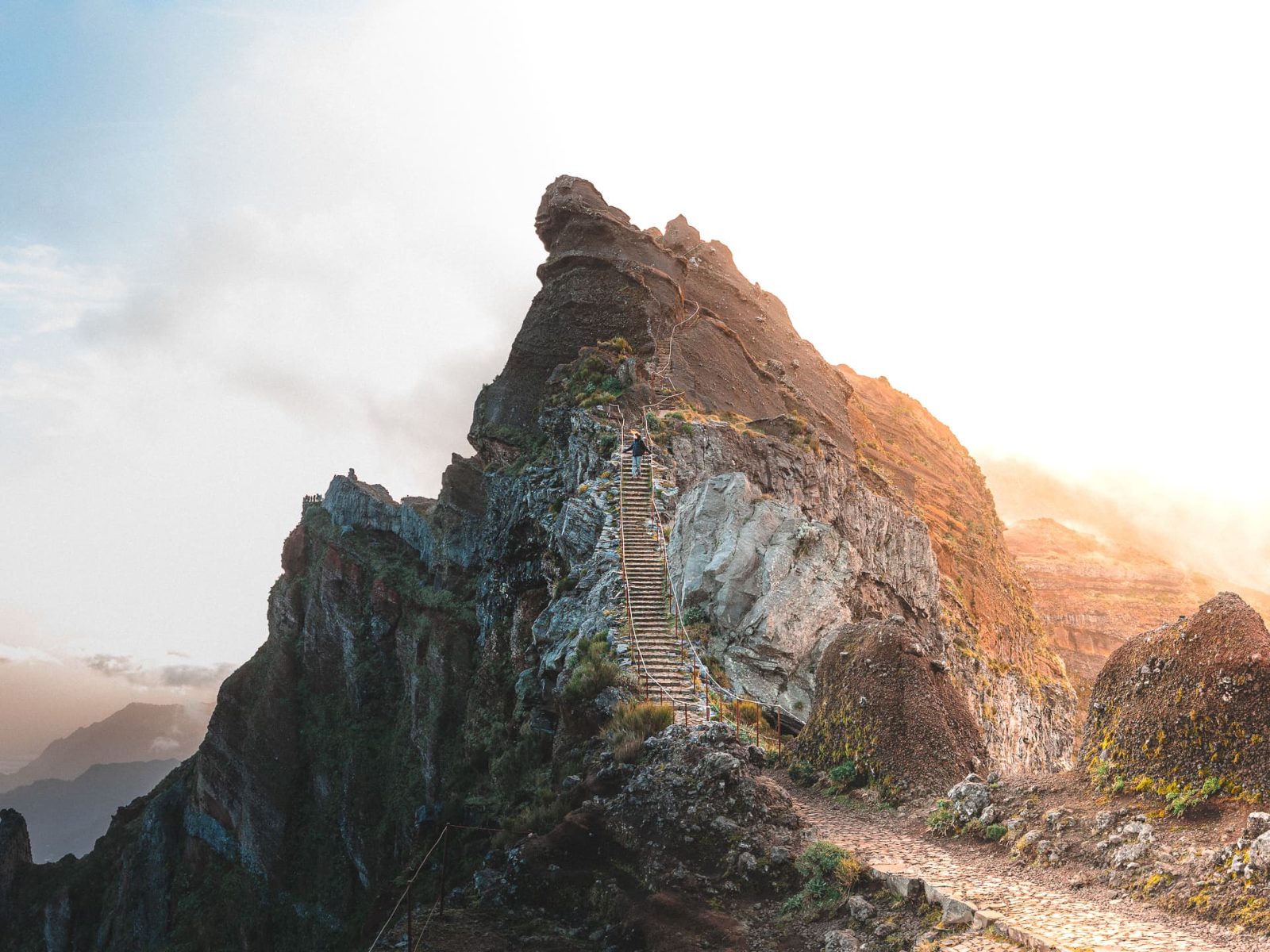
The Pico do Arieiro to Pico Ruivo hike follows a ridge spine that drops into volcanic calderas and climbs past vertical rock faces where cloud inversions roll beneath your feet. It is Madeira's most photographed mountain route and one of its most physically demanding. The trail begins at 1,818 meters and descends sharply before climbing to Pico Ruivo at 1,862 meters, the island's highest point. Between those summits lie exposed knife-edge ridges, hand-hewn tunnels blasted through basalt, and stone staircases that plunge hundreds of meters in switchbacks. The central challenge is not the distance but the constant elevation change: you lose altitude only to regain it, and the accumulated vertical effort exhausts even experienced trekkers. Sections of the path are paved, but many stretches follow uneven rock and require hands for balance. Weather shifts rapidly at this altitude—sunshine at the trailhead can become fog and wind within an hour, reducing visibility to meters. Technical difficulty sits at moderate to challenging. The route demands ankle stability, comfort with exposure, and the cardiovascular capacity to sustain effort over terrain that never flattens. Vertigo-prone hikers struggle with the ridge sections where drops fall away on both sides. Tunnel passages are short but unlit; a headlamp or phone torch is necessary. The most common mistake is underestimating the return leg, which retraces the same elevation profile in reverse and leaves many hikers depleted in the final kilometer. The PR1 trail—its official designation—connects two of the central massif's three highest summits and crosses terrain shaped by volcanic collapse and centuries of erosion. Levada channels, stone shelters, and summit refuges mark the route, remnants of the network that once served mountain shepherds and forest wardens. The landscape is raw: endemic laurel forest gives way to exposed summit plateau, and on clear days the view extends across the entire island to the Atlantic. Logistics matter. The trailhead at Pico do Arieiro lies 40 minutes by car from Funchal, and parking fills early. The conservation permit is mandatory and checked at entry points. Hikers should carry water, layered clothing, and food; no services exist along the route. Mobile reception is intermittent. Those who start late risk finishing after the official closure window, and ranger patrols enforce the 16:00 cutoff at both ends of the trail.
“The central challenge is not the distance but the constant elevation change: you lose altitude only to regain it, and the accumulated vertical effort exhausts even experienced trekkers.”
This plan suits hikers with moderate fitness covering the full 11 km round trip. The route takes 5–7 hours depending on pace and rest breaks.
Begin the trail from the summit car park at 1,818 meters. The first section descends steeply through a series of tunnels carved into the rock face, offering shelter from wind.
Follow the exposed ridge path with drop-offs on both sides, passing through additional tunnels and over metal staircases. This central segment demands concentration and covers roughly 3 km.
Arrive at Madeira's highest peak (1,862 meters) after the final ascent. Rest at the summit shelter and take in the panoramic views before turning back.
Retrace your steps along the same trail—there is no loop alternative. Budget the same time for the return, as uphill sections slow the pace.
Complete the hike and return to Pico do Arieiro before the 16:00 closure. Late finishers risk reduced shuttle availability and parking congestion.
Completing the Pico do Arieiro to Pico Ruivo hike requires securing an online conservation permit through the regional portal before you arrive. The booking and trailhead entry process takes approximately 15 minutes, after which the hike itself begins.
Navigate to https://simplifica.madeira.gov.pt and locate the Pico do Arieiro conservation permit section. Many hikers mistakenly search for "tickets" rather than "permits," which delays the process.
Choose a date within the 08:00–16:00 operating window and confirm availability. The system does not auto-suggest optimal start times, so plan to arrive between 08:00–09:00 independently.
Pay the 10.5 EUR conservation fee per person using the portal's payment gateway. Print or save the digital confirmation immediately; cell service at the trailhead is unreliable.
Drive or transfer to Pico do Areeiro, 9000-000, Madeira, and locate the marked trailhead near the parking area. Permit checks occur sporadically, so keep your confirmation accessible.
Follow the clearly marked PR1 trail signs heading toward Pico Ruivo. The initial section climbs steeply through exposed ridgeline; hikers often underestimate the elevation gain in the first kilometer.
The trail is open daily to accommodate hikers following the necessary conservation guidelines.
Many hikers underestimate the trail's technical demands and exposed sections. Proper preparation prevents the most common errors that derail this route.
Wearing trail runners on wet tunnels
The stone steps and tunnels become slick after rain or morning condensation. Ankle-supporting hiking boots with deep tread are required for the uneven rock staircases and vertical sections.
Skipping the online permit reservation
Access requires a 10.5 EUR conservation fee booked through SIMplifica before arrival. Without the digital permit, park rangers turn hikers away at the trailhead—no on-site purchase option exists.
Starting after 10:00 without headlamp backup
The 08:00–16:00 window means a late start forces you to complete 12 km of exposed ridgeline against the clock. Carry a headlamp; cloud cover or an injury can push you past official closing time.
Ignoring IPMA red-flag wind warnings
Ridge gusts above 60 km/h make the exposed sections genuinely dangerous, and the route offers no bailout points between peaks. Check the Portuguese Sea and Atmosphere Institute forecast the morning of your hike and postpone if red warnings are active.
Carrying only one liter of water
The 1,800-meter cumulative elevation gain in full sun or cloud-free exposure demands 2–3 liters per person. The route has no water sources or facilities between trailheads.
Everything you need to know about pico do arieiro to pico ruivo hike
The trek is considered strenuous due to significant elevation changes, steep staircases, and uneven terrain. Hikers should be prepared for intense physical exertion while completing this pico do arieiro to pico ruivo hike.
Yes, all visitors must secure an online permit via SIMplifica to access the trail. This conservation requirement applies to every person planning to traverse this popular route.
The best arrival window is 08:00–09:00 to avoid mid-day congestion. Arriving early helps ensure you have enough time to complete the pico do arieiro to pico ruivo hike before the official closing time.
This path is generally not recommended for young children or those without prior experience in high-altitude mountain environments. The sheer drops and demanding incline make the pico do arieiro to pico ruivo hike challenging for younger hikers.
The trailhead is accessible daily from 08:00–16:00. Please plan your return or pick-up logistics to align with these set hours.
The required conservation fee is 10.5 EUR per person. This fee must be paid online via the official permit portal before your visit.
While you can walk the trail independently, ensuring you have proper transport logistics is essential. Most visitors coordinate a transfer since the route is point-to-point and not a loop.